
Key Stats for Alder Flat
About
This trail is an easy way to get a little taste of the low elevation country for those with little time or energy. Or, it’s a nice place to spend a lot of time observing natural wonders. Offers several differing riparian settings. Passes through typical rain forest leading to a hike-in campground at the river’s edge. The toilet referred to in the USFS info sheet is no longer there. The barrier free loop was evidently not completed.
Directions
Travel Hwy 224 thru Estacada for 26 miles. Just before you get to Ripplebrook the trailhead will be on your left. A vault toilet is located at Ripplebrook to the left of the guard station a short distance up the highway.
Map and Elevation Profile
If you have issues with this page or see problems with the data, please send an email to webmaster AT trailadvocate.org with the page/trail name and details of the problem.
Trip Reports
| Photo | Date | Report Summary |
|---|---|---|
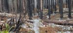 |
Dec 26, 2022 |
Trail has had work done on it since the fires
The trail has been worked on after the fires however there were a few new trees across the trail. 3 or 4 of the boardwalks/bridges in the flat area before the campground burned up in the fire and have not been replaced as of yet, but it is possible to get thru those areas with some careful routes. The campground itself by the river is mostly unburn...
|