
Key Stats for Hillockburn Trail - 516
About
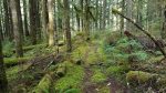
This is an easy to get to trail and a good half day romp. The trail suffered significant damage in the recent fires. Much shooting in the area on weekends and the trailhead has had a lot of illegal shooting activity in the past. No shooting signs have been posted.
There may be a sign at the trailhead (if no one has shot it to pieces). Once you enter the National Forest you climb the ridge, descend into a saddle and cross over to the other side of the ridge. At this point start climbing again about a hundred yards and there will be a parking area on the left. An abandoned spur road on your right as you pull in is the start of the trail.
The trailhead is usually accessible all year. If there is a little snow you will soon be out of it as this trail descends to the South Fork of the Clackamas.
For the savvy adventurer-woodsman, an abandoned and long unmaintained trail continues up the other side of the canyon through more untouched area for about a mile and a half to a new road about a quarter mile north of a silvaculture research area. It is fairly easy to follow to an area of giant trees and springs. Beyond this it is hard to find and there are many trees to climb over. There are often ribbons guiding the way but there are no assurances they will be there when you get there. The river is safest to ford late in the Summer and before the rains.
Both the maintained and the abandoned parts of this trail are essentially wilderness in spite of the proximity to town. All the appropriate precautions should be taken.
Directions
Travel Hwy 224 thru Estacada to the south end of town. Turn right on Hwy 211 and travel 4.8 miles to Hillockburn Road. Turn left onto Hillockburn Road (turns into Forest Road 45 after entering the National Forest) and travel 6.7 miles to the parking area on the left. There may be signs marking the trailhead.
Map and Elevation Profile
Trip Reports
| Photo | Date | Report Summary |
|---|---|---|
 |
Apr 1, 2016 |
Trail was in good shape other than shooting damage
Hiked this trail today – 4/1/2016 – good shape – only a couple of logs down on the trail. As usual a lot of shooting damage at the top of the trail – 3 trees were destroyed by shooters and have fallen at the beginning of the trail.
|