Milepost Three, Cripple Creek Trail section, FR-4635 Loop
Back last August 16 a friend (who is a fearless distance runner) and I went up the Milepost Three trail. This was one on my short list that I had wanted to get to since before the fires of 2020. I had been up the trail about 100 yards into it back before the fires, and knew it was going to be an uphill slog all the way. We departed about 11:15 AM.
The first third: The trail had considerable maintenance done on it, it almost looked like some new bench and tread was established in places. Great condition. There was fresh flagging, and although unnecessary here, it proved to be crucial further up the hill.
Second third: After crossing the creek, about a mile in, the trail became a little fainter in places. There were a few places I clipped out some vine maple and used my folding saw to cut a few larger branches. At times the flags were super helpful. I added a few more flags for good measure. Not as steep as the first part, but a lot brushier.
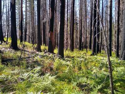
Last third (the last four uphill switchbacks): The trail was all but obliterated in places. The flags were a critical tool for progress. I added a few more and cut out many small branches. Without any doubt one of the toughest sections of trail I have ever traveled. All of the hard features were present: steep uphills, poor footing, difficult to stay on track, and lots of bushes. The last 100 yards it began to flatten out, and eventually we saw a pair of Rimrock Trail signs and knew we were up on top. I found a few spotty sections of trail. The area had obviously been pretty burnt, and the undergrowth was returning, obscuring the trail.
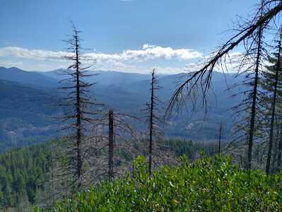
I had been up here on the Rimrock in 2019 and knew how to get to the western end small “viewpoint”. We made it there and had a short break. It was now 3:30 PM. A little more than 4 hours up.
Our plan was now to take the road back down, so we headed out. Going back down the way we came in was a bad idea we felt. The trail up here was hard to find with the new undergrowth, but I knew if we went left, eventually we would find the “marshy area”, which I knew to be about a quarter mile from the road. I recalled that there was the place that the water flowed out of the marsh, and I knew that there was a rocky section where the trail cut across the outflow. We headed cross country that way and, sure enough, there it was. The burnt area was fading, and the old trail here was now easier to discover. The trail here looked just like it did back in 2019, great trail. We popped out at the newer trailhead sign and camping area at the end of the spur road.
We travelled up the spur road and continued the main road to the campground with the North Fork of Cripple Creek running by it. We had lunch, refilled the water bottles, and ate many huckleberries. Back to the road and a short distance down I found the shortcut I had hoped to find. A little orange ribbon on a tree branch showed me the way backdown via the Cripple Creek Trail. Again, I had been here before the fires, so I knew the way. It looked as if little or no maintenance had been done on this section, but it was still in very fine condition.
We got back down to 4635, and it was smooth sailing as we went down the road. By 7:30 we were back to the car at mile post three. I believe it is unlikely that I will go up this trail again. It was certainly worth doing it once, because these are the trails that make for the legendary days.
Ted
(The two pictures below are of the burnt area at the west end of Rimrock and the view from the west end viewpoint)
Yeah, it appears there has been work done on MP3 post fire, which is good, but the areas that haven't been worked on are pretty tough. I did a trip up to the overlook a few months ago and getting up MP3 was really rough in several spots. Even knowing there the trail was in some spots was tough.
Rimrock up on top needs some help as well - since the burn the ferns have just taken over and the tread is not really evident. I was up there a couple of years ago, coming in from the east side and it wasn't bad at all, but things have really changed in the last couple of years.
I have a feeling that MP3 will be much easier in the not too distant future - it is a really nice winter access trail for the higher country (kind of like Cripple Creek is).
Thanks for the trip report - I was interested to hear about the upper Cripple Creek trail as I'd heard it had maintenance post fire - it is amazing how quickly things can change now that light is getting down to the forest floor in the burned areas!


