
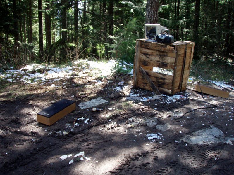
So I decided to get out for a quick hike today to take advantage of the GREAT weather. I didn't have a lot of time, so I decided to do the Hillockburn trail. The trailhead was a MESS - I don't remember it being that bad, and to make matters even worse, it looked like they might have been shooting right down the beginning of the trail!
It was a beautiful day, and I only saw one other group on the trail - I ended up spending a little bit of time down by the river, which was very peaceful. It was obvious that someone had camped there recently, and had quite a bit of firewood split (from some of the downed trees that had been cut). There had been some work done on the trail as well, although the trail was in pretty good condition. A couple of the switchbacks had washed out a little bit, but were still easily traversable.
There is a comment on the page for this trail saying there is a "abandoned and long unmaintained trail" on the other side of the river. I spent a while looking for the trail, but didn't see anything terribly obvious. I took the following photo and drew a line on it where I thought the trail might have been:
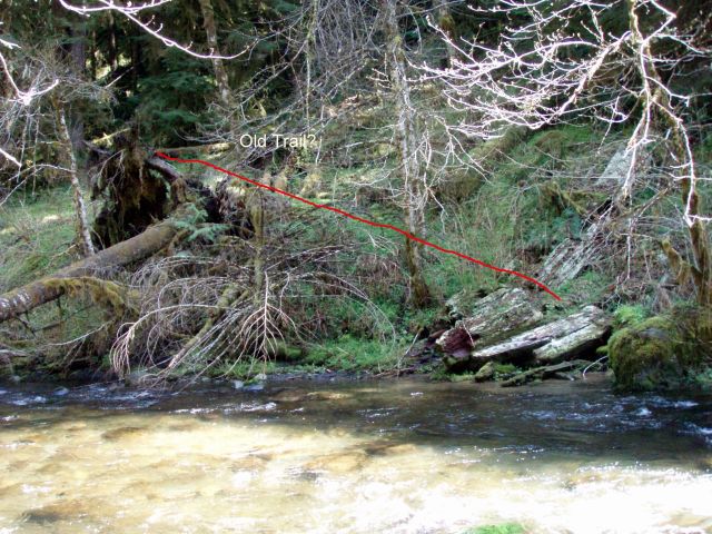
If this is truly the trail, it is VERY faint.....I took a look at some old maps and it doesn't look like it has been on a map in over 50 years. Does anyone know if that is the trail? It kind of looked like a trail bench, but it wasn't an obvious one.
That's it. Some new blow down. Is that hemplck stretching across the river?
The trail becomes more distinct just up out of sight.
The trail head is an unfortunate spot. I hope you left the trash. That's how they like it.
D.
There are a couple of trees that were almost across the river, but not quite. All the devil's club makes it tough to get to the river, except in one spot. I think there is a larger tree that pretty much goes across a little upstream, but it might be tough to get back to the trail. Exploring for a different day, wtih more time. Maybe in the fall when the water is lower.
Just to show you how bad the trailhead is, here is a photo at the top of that old spur road - there is a little snow, but most of it is garbage and debris from the shooters, and no, I didn't pick any of it up - there were shooters on the other side of the road when I came back up:
Rob Williams said:
There are a couple of trees that were almost across the river, but not quite. All the devil's club makes it tough to get to the river, except in one spot. I think there is a larger tree that pretty much goes across a little upstream, but it might be tough to get back to the trail. Exploring for a different day, wtih more time. Maybe in the fall when the water is lower.
Just to show you how bad the trailhead is, here is a photo at the top of that old spur road - there is a little snow, but most of it is garbage and debris from the shooters, and no, I didn't pick any of it up - there were shooters on the other side of the road when I came back up:
Classic picture. The Urban/Wilderness Interface.
Donovan
That trailhead is always a party spot through the winter, too bad for it is a nice trail. Rob was there any more ATV damage down the trail that you could see? I know just before the trail was put into wilderness we were having trouble with motorcycles and quads going down the trail. The trail does continue across the southfork, but goes through an experimental tree farm for the USFS with locked gate and tall fences. Bummer!
Don