I didn't like this quote I just read. 
Oregon 224 will remain closed indefinitely south of town -- perhaps even after firefighters have left the area -- because of landslides, said incident commander Bruce Holloway.
"The fire has gone up there and burned the vegetation off,'' Holloway said. "It loosens boulders, dead trees fall over and they're sliding down on the road. It's not just a few rocks, it's actual landslides."
Keeping 224 closed will most likely be an unfortunate reality. If you go back to the video of the snowplow that kirk posted, you can see when the vehicle went around a slide that blocked half the road. It hasn't started raining yet, and when it does expect large amounts of debris and not just near streams. I remember after The Falls Fire in the Gorge and the road not just blocked but buried a yard or two and sometimes much more for long distances.
The Bowl Fire several years back was not far upstream from the current fire. It was entirely south of the river. Most of the old firs survived, with thin-barked maple and cottonwood the main fatalities along with most of the shrubs (many of which resprouted). Almost all of that burn was ground fires only. It was entirely driven by downstream winds, like at the beginning of 36 Pit.
Our big unknown is how much of this burn is ground fires only and how much stand-replacing crown fires or torching. That tidbit of information isn't making the news and probably never will.
I heartily recommend viewing the Google Earth kml fire "incident perimeters" available at http://inciweb.nwcg.gov/incident/4106/ in the right sidebar. The Google ruler tool is easy to use and provides simple distance measurement. For example, the 50 acre spot fire - which is now stopped - was only a quarter mile from the nearest homestead structures. That's a few minutes burn time under extreme conditions, which don't exist now but could return for the weekend. It also shows that at the moment the fire boundaries were drawn (infrared flight at 1:42 AM) the fire was still uphill from Carter Bridge Campground. Firefighters have been known to perform heroics to save campgrounds in the past and that provides some hope for the four campgrounds now so close to the burns edge.
The best news yet is a 70% chance of rain next Wednesday. They are giving a 40% chance tonight.
Check this article out on the cause: /local/Man-says-he-saw-start-of-36-Pit-fire-near-Estacada-275367601.html?tab=video&c=y
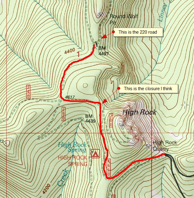
Speaking of road closures, I was on the FS website tonight and it said that the junction 4610.220 to junction 5800 closed 9/14/14 due to 36 Pit Fire. I couldn't find the 4610.220 road on our district map. Am I loosing it or just need to renew my eyeglass prescription? I know the 4610.240 is the Frazier Road; 4610.190 is the High Rock Springs Road; and 4610.200 is by High Rock, but I'm not seeing 4610.220. Just scratching my head here.
Update on the 4610.220 road! Luckily I found my Zigzag district map that shows the 4610.220 road just to the north of High Rock. Our district map has the map legend box on that spot of the map. So that tells me the FS shutdown the upper access to the Roaring River Wilderness. So no Hambone or Frazier Turnaround access, is that what I'm seeing? If I was the district ranger, I probably would have done the same thing until they get control of this fire. It's not over yet folks!
UGH! It looks like you are correct, Don. Looks like they cut off access to High Rock, High Rock Spring campground, Linney, Hambone and Frazier Turnaround. I guess that kind of makes sense due to the volatile nature of the fire, but it really sucks!
It sounds like they are starting to get a handle on the fire, with something like 800 people working on it now. It is possible they will remove this closure soon, but I wouldn't bet on it.

Interestingly enough, Frazier Turnaround is not part of the closure area. The closure area stops at the Roaring River:
http://www.fs.usda.gov/Internet/FSE_DOCUMENTS/stelprd3816844.pdf
