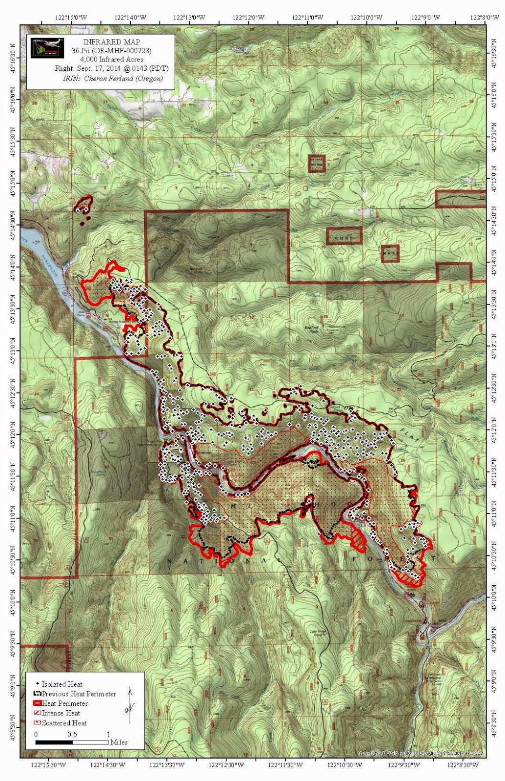
Here's today's fire map. It looks like there wasn't much growth on the western and eastern fronts, but it's still creeping along the steep hillsides.

Looks like Carter Bridge campground is toast.... But at least the rate of growth has slowed for the moment. Only about 500 acres yesterday.
Hoping for rain. The weekend isn't going to be kind - sounds like it is going to get hot again. Hopefully it will give them some time to establish a perimeter before the heat cranks up again.
They may have been able to save the campground. Hard to say until tomorrow's map is released.
Here's an update:
09/17/2014 Fire Update 26 Pit Fire
Incident: 36 Pit Fire Wildfire
Released: 52 min. ago
Washington IMT 2 Incident Commander – Bruce Holloway
ODF Incident Commander – Russ Lane
Oregon Fire Marshal Blue Team Incident Commander – Scott Magers
36 Pit Fire Update
September 17, 2014 – 1:00 PM
FIRE INFORMATION WEBSITE: http://inciweb.nwcg.gov/incident/4106/
INFO PHONE: 360-280-4352 or 503-630-1711
EMAIL: 36pitfire@gmail.com
Fire Information Office Hours: 8:00 am -8:00 pm
Excellent progress to contain the 36 Pit Fire occurred yesterday along the northern and western perimeters of the fire. Dozer and hand lines were constructed to contain portions of the fire’s northern perimeter. Natural features and Road 4610 are also being used to contain the fire on the northern flank. The highest priority is to continue to hold and contain the western and northern portions of the fire since these locations are closest to any structures, industrial forest land, and other resource values.
Yesterday, burn out operations went well in the vicinity of the Silver Fox RV Park creating a smoke plume that was visible to many residents of the Estacada area. Yesterday afternoon and through part of last night’s shift, fire crews burned out fuel located between Road 4610 and Highway 224 near the Silver Fox RV Park. However, last night, increased humidity caused burn out operations to be suspended. Today, as temperatures increase and relative humidities decrease, firefighters intend to complete the burn out near the Silver Fox RV Park. Burn out will continue to happen at the north and the northwest portions of the fire. Burn out of fuels is a fire suppression tactic used to reinforce fire lines and to consume fuels adjacent to structures. Residents of the Estacada area may see visible smoke as burn out operations proceed.
Along the southern perimeter of the fire, firefighters continue to identify roads and other locations where they can safely contain the fire. However, there may be opportunities to build containment directly adjacent to the fire dependent on favorable weather conditions. Firefighters are contending with very steep terrain and are evaluating locations where fire line can be safely constructed.
A Unified Command led by Incident Commander Russ Lane of the Oregon State Department of Forestry, Bruce Holloway of Washington Incident Management Team 2, and Scott Magers of the Oregon State Fire Marshal Blue Team are leading the fire suppression effort. The local Estacada fire District 69 has been heavily involved in the fire suppression efforts. Structure protection task forces and Blue Team management personnel mobilized under the Oregon State Conflagration Act continue to work on the north and west side of the fire, assisting with protection and mop up operations around those affected homes, including the Silver Fox RV Park. Structure protection resource needs will continue to be evaluated throughout today and will likely begin to demobilize over the next couple of days as the threat to those structures lessen.
Looks like the old bridge over the south fork is right at the edge of the burn. Really hoping it survived. The sign on the Christian camp trail also looks to have survived. Gonna be very wierd seeing all the burnt hills.
Here's a link to a blog about smoke from the various wildfires around the state:
http://oregonsmoke.blogspot.com/
