I've been watching the inciweb site for updates, but nothing as of yet, and I don't see any maps posted to that site. I did find an update on a news site that said the fire is now 2300 acres and growing:
http://www.kptv.com/story/26526422/crews-battling-30-acre-fire-near-estacada
I guess it crossed the river last night. This is going to be really bad....It has engulfed part of the 45 road and is getting close to all the stuff at North Fork/Promontory. It is going to be a surreal scene whenever we can get back up there.
Looks like it got the weigh station and the beginning of FR45. Wow!
The confluence of the South Fork had some big old growth, gonna be very surreal rounding that bend and seeing it all burnt.
I have a feeling we haven't seen the beginning of this one. I think it is going to get a lot worse before it gets better. I sincerely hope I'm wrong, but it seems to be completely out of control right now.
It is going to be very surreal once we can get back in there - but I think that might not happen for a while.
Agreed that this has the potential to be really bad but all we city folks can do is watch.
There are three weather issues that could or will change fire behavior.
There is a some chance of dry lightning tonight. The further east the more likely but any new fires will be a major issue if they occur.
There is a 20-40% chance of light rain starting Wednesday. It may be spotty and too light to do more than slow the fire. Back to dry and sunny by the weekend.
Wind will shift to S-SW, encouraging fire spread in a broad and uncertain arc from perhaps the Nudist Camp to Salmon-Huck Wilderness and Roaring River. There are some roads that direction to fight the fire from. Winds diverted by topography to follow the Clackamas could encourage spread upstream. Spread towards Hillockburn and Estacada will be limited by this compared to previous spread by east winds.
They've closed Roads 45 & 46. They are sending campers stuck upstream out 57 or 42 to Hwy. 26.
Some news photos show ground fire under large firs (KPTV) and hopefully this will be the case in the remnant old growth along the river. Pray the big old ones survive.
It just took be half an hour to get the inciweb site for this fire. Its getting overloaded thats for sure, but there is a nice new report and a map. Be sure to remember these outline maps include sometimes large unburned areas.
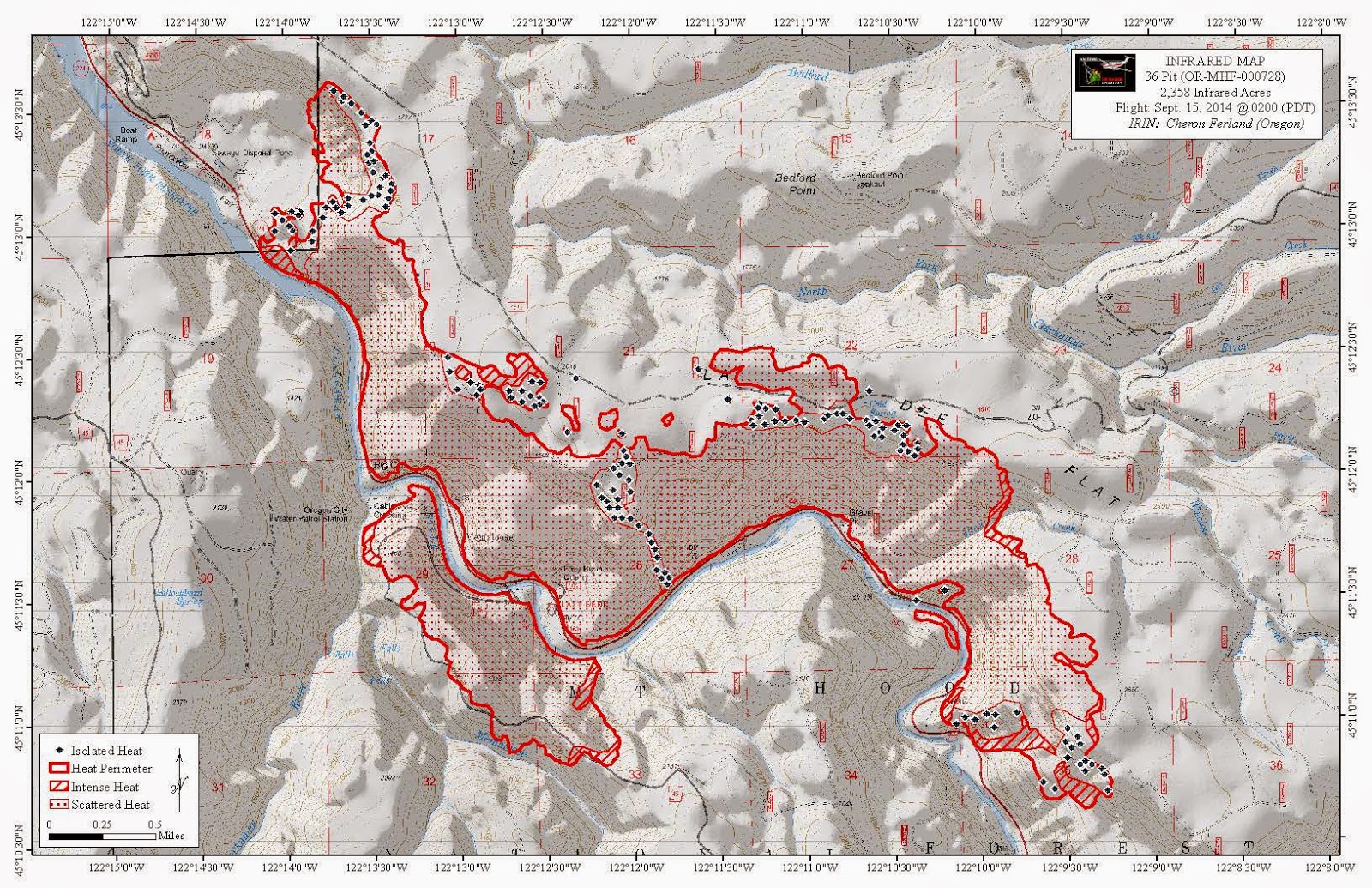
Here's an interesting map I found. It shows different levels of heat in the fire area. It's kind of grainy, but I guess it takes up less memory that way. I found it at: http://www.nwccinfo.blogspot.com/

