
It will be June or July before you get up on top, at least that has been my experience. I have always wanted to hike across the southside of Granite Peaks with all those unusual rock formations. Now it kind of makes sense it being a volcano, with the north rim still there. I haven't looked at a geological map of the area, but now you have renewed my interest.
Road Decomissioning
Wow. I took a look at a few of the documents, and there are some "major" (not spur) roads that are marked for "Decomission with delay (5-10 yrs)". I'm guessing that means they won't be decomissioned now, but will be in 5-10 years? I'm wondering what would determine whether it would get decomissioned in 5 years or 10? How do they determine when it is time to decomission it?
Pretty much all of roads 6311, 6320, 6330, 6341, 6344, 6370, 7010, 7040 are marked for being gone in 5-10 years. Getting rid of all of the little spur roads makes sense, but some of these roads seem to be the only road in the area. For example, 6341 would disappear shortly after the Pansy Lake trailhead, but it continues along for a quite a while up the valley.
It also appears we would lose access to the Baty Butte trailhead, as the 7010-160 spur would disappear.....Maybe they think we can access it from the other side. There are probably others that I haven't seen, since I just took a quick look this morning.
Rob, the scoping letter posted with the maps lays out their objectives as follows:
- Reduce impacts to water quality and aquatic habitats associated with unneeded roads.
- Reduce road density to improve terrestrial habitat utilization.
- Reduce the spread of non-native invasive plants associated with unneeded roads.
- Reduce road maintenance costs.
The first and last bullets are the drivers -- and especially the last one. At this point, they've got such a huge maintenance backlog, and no new revenue source in sight, that this was sort of the obvious outcome. What surprises me is that they're actually decommissioning (or proposing to) a number of roads, and that costs money.
I suspect their scientists are telling them that simply closing the roads will leave them vulnerable to collapse in steep terrain, making matters worse in already heavily impacted areas -- and possibly putting them in violation of the ESA if known salmon and steelhead habitat is destroyed through lack of preventative action.
As far as the delay, I don't know the official answer, but I suspect they still have timber sales to deliver on some of the route, or perhaps are planning salvage and thinning operations in some of these areas. In other areas where they have already gone through this process, some roads in the final action were simply left "closed" -- meaning gated or barricaded and not maintained -- while others were "decommissioned", and you've probably encountered one of those.
BTW, to the credit of the USFS, they do appear to be trying to maintain trailhead access in most cases, and this round of maps is a BIG improvement over those covering the Upper Clackamas, earlier this year. That set included no trail information, and no landmarks except streams, which made for a tedious review. I think they heard from a number of us who commented, and improved the maps this time.
They released a similar set of proposed closures/decommissions for Wildcat Mountain and north side of Zigzag Mountain last fall, in similar fashion, so they are covering a LOT of ground.
Tom
Back to Granite Peaks, here's a clip from the geologic map - this is very small scale, so I've included the Collawash/Clackamas and Timothy Lake as references. The Rock Lakes Basin also jumps out on this map (with a couple volcanoes mapped on the little divide between the Cot Creek and Shellrock Creek drainages).
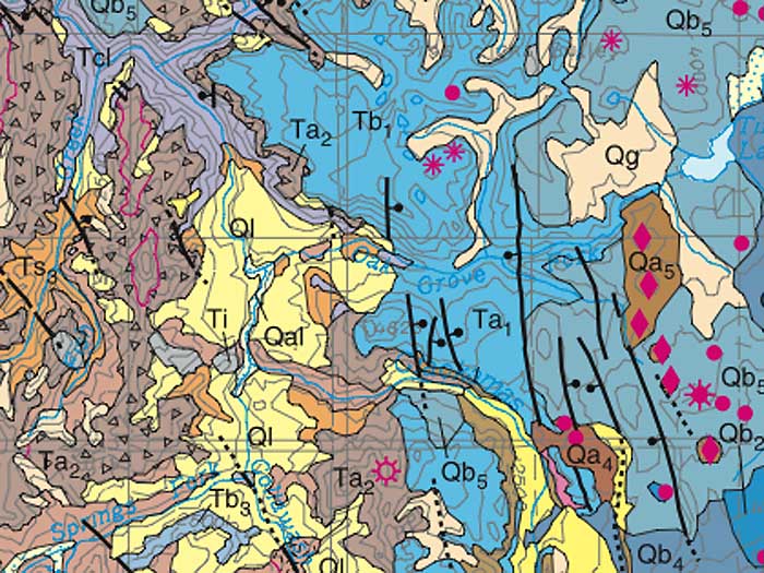
The "Ta2" symbol is right on top of the Granite Peaks (and the designation refers to Tertiary Andesite). The symbol of an open circle with radiating hash marks denotes a composite volcano. At this scale, the fact that it's centered on the ridge just east of the main Granite Peaks crest isn't as significant as simply having the group of peaks identified as a composite volcano.
That means the geologic studies points to a potentially much larger peak here (probably like one of the smaller Cascade Crest volcanoes, like Ollalie Butte). The "Qb" symbol denotes younger basalts to the east, and the "Ql" (yellow areas) are younger landslide and debris flow formations. I suspect these surrounding features were part of the conclusion that Granite Peaks/Mt. Lowe are the core of a much larger volcano -- plus likely research on road cuts in the area.
Okay... enough geology... again!
Tom
Tom Kloster said:
The first and last bullets are the drivers -- and especially the last one. At this point, they've got such a huge maintenance backlog, and no new revenue source in sight, that this was sort of the obvious outcome. What surprises me is that they're actually decommissioning (or proposing to) a number of roads, and that costs money.
That surprises me as well. I don't really understand how ripping up a road will make it any different than an abandoned road. If the road were paved I can understand, siunce you are removing the hard surface, but for a gravel road, it seems all that happens is that the surface becomes VERY uneven. Water would still percilate through the road the same way it seems no matter whether it were ripped up or abandoned.
If they were actually able to do more work (i.e. grading and brushing) of the existing roads, I wouldn't be averse to removing some of the "other" roads. What bothers me is roads that have become so washboarded they are tough to drive on, or they are so brushed in, you can't drive on them unless you want to scrape up your vehicle.