
Greetings, Advocates!
I'm researching the trail history in the Granite Peaks area, and am hoping one of the experts here can fill in some of the blanks. First, I am a bit surprised to see that the only routes in the vicinity of the peaks, proper, were the old transect trail on the north side that has more or less been replaced by Road 6310 and a secondary trail up Buckeye Creek. These routes can be seen on this clip from the 1938 topographic map of MHNF (along with the lookouts on Burnt Granite and Mt. Lowe, and the associated trails and wires):
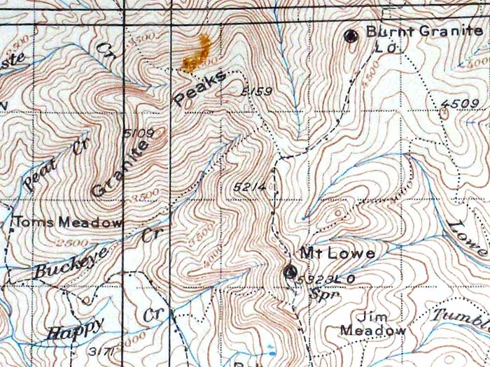
Given the rugged, prominent nature of Granite Peaks, I'm surprised there wasn't more activity — or perhaps even a lookout — back in the day. The peaks form a fairly high ridge (four of the summits crest 5,000, and are only about 100 feet shorter than Mt. Lowe) and the area to the west drops off to the broad Collowash-Clackamas confluence, with Fish Creek Mountain the next major peak to the west.
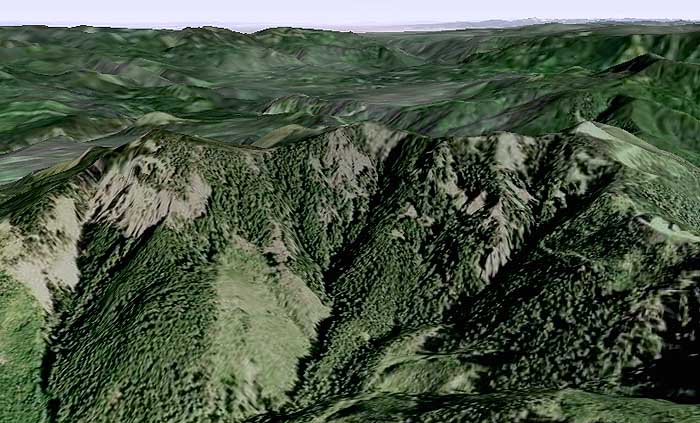
This can best be appreciated with a Google Earth view of the Granite Peaks, looking to the northwest, with Fish Creek Mountain on the left, the Silver Star Range on the far right horizon and the flats of Portland on the horizon, center — lots of visible forest terrain in-between that presumably couldn't be seen as well from either the Burnt Granite or Mt. Lowe lookouts:
I haven't explored the peaks on foot, at all. So, while I'm skeptical about the geology actually being "granite", I am wondering if there are some igneous formations that might be similar to some of the stuff in the Bull of the Woods and Opal Creek areas… and if so, whether there might have been mining in the area that led to the naming of the peaks..?
BTW, the backstory on my research interest is the USFS proposal to decommission a bunch of roads in the area, and in particular, access to trails and trailheads that might be affected.
Thanks in advance for any light you can shed!
Tom Kloster
Tom
I have done some exploring in the upper reaches of Buckeye Creek near the 6310 road, but haven't found anything conclusive otherthan a game /access trail coming up through a low pass on the ridge south of the Granite Peaks. Someone had recently in the last year or so cutout some of the logs the were across the trail that leads down into some meadows south of the peaks. Not sure if it was for a wildflower study, for the area is rich in plant diversity, or some hunters or other users in the area.
Most of all of the spur roads put in to log the peaks area have already been decomissioned and I am sure other roads in the area are earmarked to be also. The lower Buckeye Creek area looks like it has seen alot of disturbance from the logging and roadbuilding and I am not sure if there are any traces left of that trail coming up the creek or not. Like I said I have only looked up on top and haven't explored the bottom end.
Don
Thanks, Don -- I'll have to take another look to locate those meadows. I'm eager to get up there... already starting my summer hiking plans!
I did check the geologic maps, and though the area is pretty generic for the Cascades (the Granite Peaks are, in fact, largely andesite, and Mt. Lowe and Burnt Granite are overlying basalt), the complex of peaks is mapped as a composite volcano, centered on the north pair of Granite Peaks. This is quite unique, as Mount Hood and Lookout Mountain are the only other peaks in the MHNF are mapped as composite volcanoes. Everything else falls into the small volcano category (shield volcanoes, andesite cones, etc). So this makes the Granite Peaks complex quite unique -- more like the High Cascade volcanoes in origin than most of the surrounding peaks.
Okay, enough geology..!
I hope I don't smell yet another damn wilderness.
Or what I meant to say is, there's nothing there of any interest that I know of.
Donovan
Not that I'm aware of - just an opportunity to undo some of the logging road system where it never should been built. In this case, the Collawash watershed is the focus, and thus this particular corner. But the USFS is doing the proposals, and they're being quite bold in what they proposing, too.
This is a watershed event (no pun intended) for the MHNF that is surprisingly below-the-radar, given the decades of warring over roads and logging. I give them (the MHNF) credit for trying to figure out what a minimum level of service roads looks like in scaling back the system to some sustainable level.
It's important to weigh in where trails are affected, and especially where roads can be converted to become trails as part of the road closure process. Anyone interested in this can look at the "current projects" area on the MHNF site, and download maps of the proposals under the "Collawash Road Decommissioning" heading.
Tom