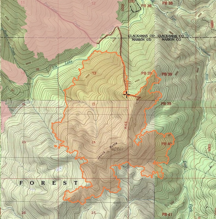
The Janus, Cola and Ridge Fires are in the southeast corner of the Bull of the Woods Wilderness in the Janus Butte area. Two more fires are the Round Lake and Ogre Creek Fires, located in the Round Lake area east of the Bull of the Woods Wilderness. All are being managed as one fire, called the Bull Complex.
The Janus Fire is about 350 acres and is actively spreading. All the others are small, but only the Round Lake and Ogre Creek Fires are being fought at the moment. Planning to fight the other three is ongoing.
It is very uncertain about what to expect, with weather short-term a little wet and cool, but getting sunny and warming to around 90 up there by the middle of next week.
https://inciweb.nwcg.gov/incident/7773/
Thanks for posting this. Lets hope it doesn't grow too large. Too much of the Bull has already burned....
If you want to see the fire overlaid on a topo map (instead of the horrible map that inciweb uses), you can see it here:
http://trailadvocate.org/MapViewer.html?ll=44.86891,-122.01193&o1=24&z=14
That will display the fire perimeter of the various blazes relatively centered on the page.
I was up on Rho Ridge Friday afternoon... I came in from the north via 4670. It was pretty smoky, and bad enough that I could barely see Sisi Butte.
I had planned on walking up the decommissioned road next to Fawn Meadow and across the ridge to see across the backside of the hill and into the Collawash valley. I was just about to leave 6350 road and go into the meadow area when a truck came down the road. A man flagged me down and asked what the heck I was doing up here. He said he was part of the fire crew and recommended that I head back down the hill, please. I said okay, and went back north on the ridge.
When I got back to the 46 and 4690 (Olallie lake road) junction I chatted a bit with the USFS staff that was posted at the barrier. I could see that a fire basecamp had been set up in the Squirrel quarry area. As we chatted quite a few vehicles went in and out. They're pretty busy. He said that they were going to move the barriers Sunday and close off the access to 46 from 4690. He said that it would be closed until the fire situation was dealt with.
So, it looks like the upper Clackamas valley and BOTW will be closed for a while... It was fun while it lasted...
Ted
p.s. Sorry I missed Doug's post of the closure order...
Here's a bonus: There is now some gear installed to count radio tags in fish across Pinhead Creek just above where it cuts under 46 now. I suspect that it is a continuation of the bull trout reintroduction program. I am glad that nobody can mess with their equipment now... probably the only good thing about this closure...
Ted:
I'm assuming 42 is still closed where they are replacing the bridge? It was scheduled to be closed until the end of August, but I guess it doesn't really matter now. The only thing you can get to is Olallie now. I understand the closure but it is a bummer....
From the map, it looks like they've dealt with all the little spot fires - those no longer even show up on the map - even around Round Lake - the only thing that shows is around Janus Butte which was always the largest piece. Hopefully they get a handle on it. Looks like it is getting VERY close to where it burned in the BOTW fire from 2010:

I saw the lower 42 closure from the 46 road. It was closed about 100 feet up 42...
The Elk Lake Eastern trailhead is probably the only good access to the fire area. I would expect a containment fireline on the Elk Lake trail.
When I look at the map you just posted I realized how close the fire is getting to the "Bridge to Nowhere"... I always liked that place... and of course that means the "OhBoy Forest Camp" artifact is now at risk too. I was there a few years back. I bushwhacked my way in and then found the much easier trail out... Seems that happens to me a lot...
Looks like the fire has grown by about 300 acres in the last day... now up to almost 1200 acres. ugh.
